Topographical survey of a 40,000 m² development site

A property developer needed a full picture of a mixed-use site in North Wales before planning and design. We surveyed every field, building and boundary, plus the A-road alongside, and handed over drawings ready to design on.

40,000 m². One base drawing.

Fields, industrial land and an A-road, surveyed together so every consultant works from the same sheet.

The project

Overview

We were appointed by a property developer to complete a full topographical survey of a 40,000 m² site in North Wales. The site mixed open agricultural fields, industrial land and zones earmarked for future development, so the survey had to serve several different design questions at once.

Survey scope

We recorded hedgerows, scattered trees (with trunk diameters and canopy spreads), industrial buildings and areas of hardstanding. The adjacent A-road was surveyed too, to inform access, drainage and traffic planning.

Method

All visible above-ground services were levelled and mapped, including manholes, gullies and inspection chambers. A 10 m grid was applied across the open areas for consistent ground modelling, and precision GPS and total stations kept the data accurate throughout.

Deliverables and outcome

We delivered CAD and PDF topographic drawings tailored to the client's needs. The survey became a key planning tool, letting the project move forward efficiently and the design team make informed decisions from the start.
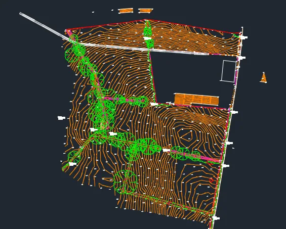
Topographical survey drawing on a dark CAD background: dense orange contour lines across fields, green tree canopies along hedgerows and red site boundaries
Project
Development site
Location
North Wales
Service
Topographical survey

Extract from a Gora topographical survey drawing: contours across open fields, with trees and hedgerows along the boundaries.
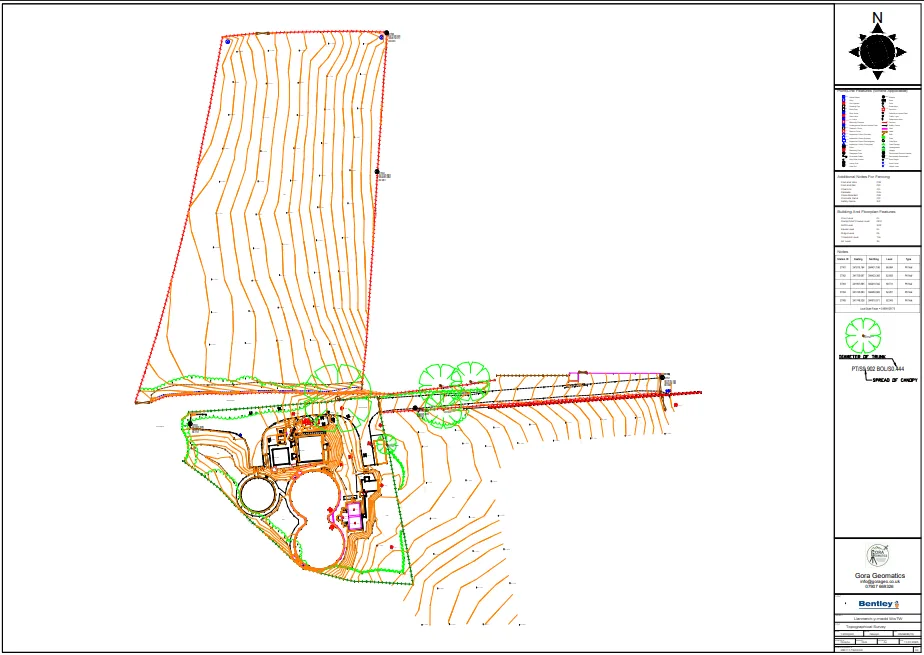
Gora Geomatics topographical survey drawing: orange contour lines across a field, green tree canopies, site boundaries and a title block
Drawing
Topographical survey
Location
North Wales
Service
Land & topographical surveys

Another of our topographical surveys, issued with a full key and title block.

What a survey like this gives a developer

A topographical survey isn't just a drawing for the planning file. It answers the questions every consultant on the team will ask.

How our topographical surveys work

  • Accurate levels

    For layout, drainage and earthworks design.

  • Trees and canopies

    Positions and spreads for arboricultural and planning work.

  • Road and access

    Detail for highways discussions.

  • Covers and chambers

    So drainage connections can be planned.

  • One base drawing

    Georeferenced, for every consultant to work from.

More case studies

Need your site surveyed?

Send the site location and tell us what the survey is for. We'll agree the scope and grid with you and send a clear quote.

Talk to an engineering surveyor
07907 669326

Monday to Friday

Get a quote

Ask us for a quote and we'll get back to you as soon as we can.