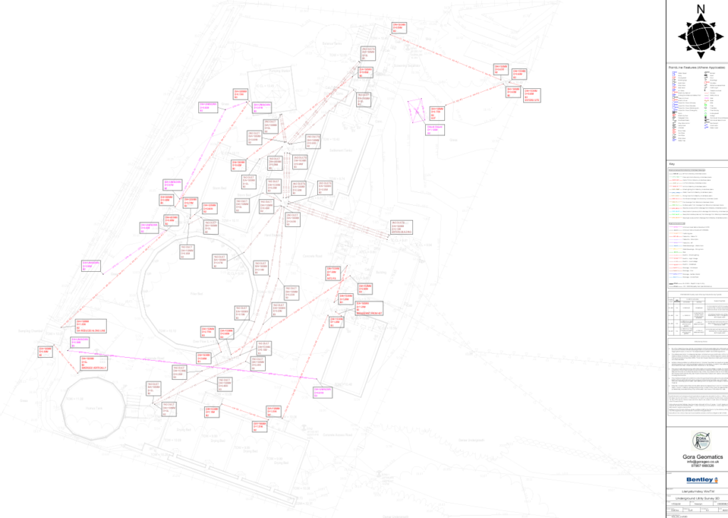
PAS 128 Utility Surveys
PAS 128 Utility Surveys in North Wales
We provide PAS 128-compliant utility surveys across North Wales and the North West of England, using Ground Penetrating Radar (GPR) and advanced detection techniques to accurately locate underground services.
Our surveys help reduce risk, prevent costly service strikes, and support safer planning and construction.
What Is a PAS 128 Utility Survey?
PAS 128 is the UK standard for underground utility detection and mapping. It sets clear requirements for survey methods, accuracy levels, data quality and reporting.
A PAS 128 utility survey identifies both known and unknown services, including:
Electricity
Gas
Water
Telecoms
Drainage
Unknown or unrecorded utilities
This information is essential before excavation, groundworks or design finalisation.
Our Utility Survey Services
We deliver clear, reliable underground utility data to support projects at every stage.
Our services include:
PAS 128-compliant utility surveys
Ground Penetrating Radar (GPR) surveys
Electromagnetic location (EML) surveys
Utility tracing and verification
Depth estimation and positional accuracy
As-built utility mapping
All surveys are carried out by experienced engineers following current PAS 128 guidance.

Ground Penetrating Radar (GPR)
GPR allows us to detect both metallic and non-metallic services, including plastic pipes and unknown obstructions that traditional methods may miss.
GPR is particularly effective where records are incomplete or unreliable and provides valuable insight into buried structures and services.
Survey Outputs & Deliverables
We provide clear, usable outputs tailored to your project needs, including:
Colour-coded on-site service markings
Georeferenced digital survey data
CAD-compatible drawings
BIM-ready utility models
Clear confidence levels in line with PAS 128
Our data integrates seamlessly with design, planning and construction workflows.
Reducing Risk on Site
Utility strikes are a major cause of delays, damage and safety incidents. Our PAS 128 utility surveys help:
Reduce the risk of service strikes
Improve site safety
Support informed design decisions
Avoid costly delays and repairs
Provide confidence before excavation
Whether you are at early design stage or about to break ground, accurate utility information is essential.
All Services
Land & Topographical Surveys
Accurate site surveys providing detailed level and feature data to support planning, design and construction.
Machine Control & Digital Terrain Modelling
3D terrain models and machine control data to improve accuracy, efficiency and productivity on site.
Site Setting Out
Precise engineering setting out to ensure construction works are built exactly to design.
PAS 128 Utility Surveys & GPR
Underground utility detection surveys to reduce risk and support safe excavation and design.
Volume & Quantity Surveys
Reliable earthworks volume calculations for cost control, planning and progress tracking.
Get a Quote
If you need reliable surveying or engineering support for your project, get in touch with our team today.
We provide clear advice, accurate data and fast turnaround across North Wales and the North West of England.