
Machine Cotrol & DTM
Machine Control Models & Digital Terrain Modelling (DTM) North Wales
We provide high-accuracy machine control models and Digital Terrain Models (DTM) for construction and earthworks projects across North Wales and the North West of England. Our models help operators, engineers and designers work faster, safer and more efficiently-reducing rework, improving accuracy and keeping projects on programme.
Whether you need data for bulk earthworks, road construction, drainage, utilities or complex infrastructure, we tailor every DTM to your project requirements and machine format.
What Is Machine Control?
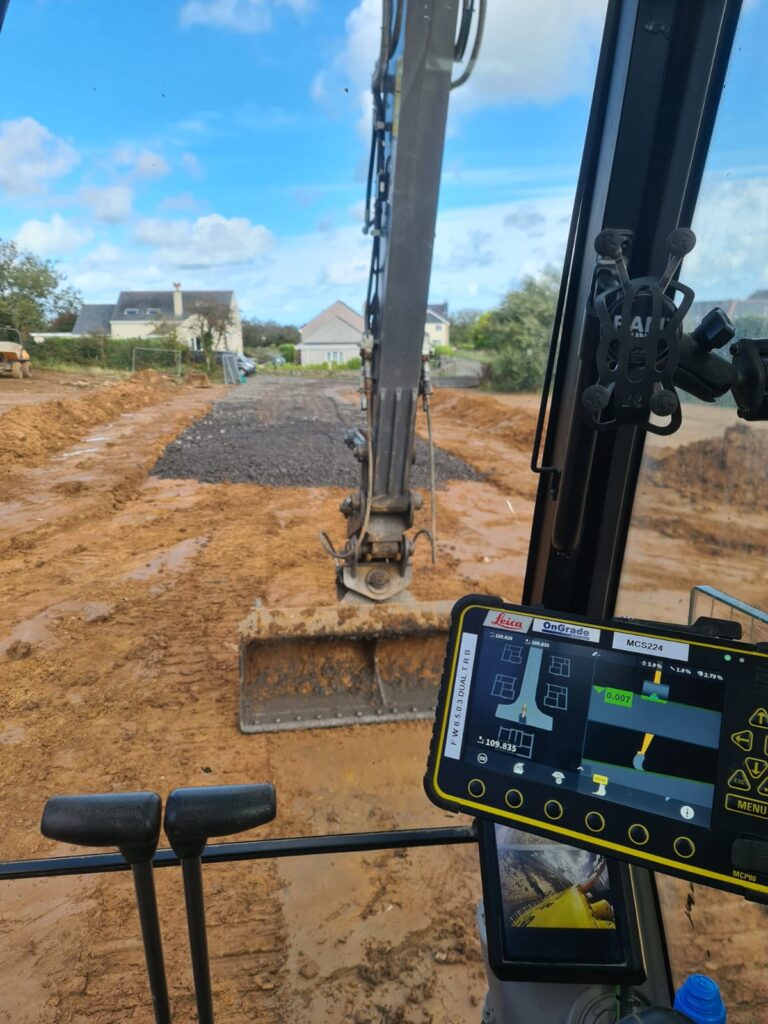
Machine control uses GNSS, total stations and 3D terrain models to guide plant machinery with precision. This ensures excavation, trimming, grading and drainage works match design levels accurately.
Machine control improves:
Accuracy
Productivity
Safety
Fuel efficiency
Cost certainty
It’s now essential for modern earthworks and engineering projects.
What We Provide
Our machine control and DTM services include:
3D Digital Terrain Modelling (DTM)
Trimble, Leica & Topcon machine control files
GPS/GNSS-ready data
Structural, drainage and utilities modelling
Pre-construction earthworks analysis
Road alignment and corridor modelling
Finished surface models
Design model verification
Cut/fill surface comparisons
All models are built according to your design drawings and specification.
Supported Formats & Equipment
If needed, we can liaise directly with your designer or machine control specialist to ensure the data is compatible and ready for immediate use.
Trimble Earthworks
Designed for modern earthmoving operations, Trimble Earthworks provides real-time guidance using 3D models to improve accuracy, productivity and on-site efficiency across large construction sites.
Leica MC1 / iCON
Leica MC1 and iCON systems deliver high-precision machine control and positioning, ideal for detailed construction works where accuracy, consistency and tight tolerances are critical.
Topcon 3D-MC
Topcon 3D-MC supports complex construction and earthworks projects, using advanced 3D control to handle intricate designs, structural elements and challenging site conditions with confidence.
GNSS and robotic total station workflows
By combining GNSS and robotic total station workflows, we provide flexible machine control and surveying solutions for cut and fill, stockpiles, quarries and large-scale earthworks.
Typical Applications
Our models support a wide range of construction activities:
Bulk excavation & filling
Road & pavement trimming
Embankment construction
Drainage excavation
Service trenches & avoidance zones
Landscaping & regrading
Platform and pad construction
Quarry and minerals work
How We Build Your DTM
We follow a clear, industry-proven workflow to ensure accuracy:
1. Receive and review drawings
We check for layers, missing levels, design issues or conflicts.
2. Process, refine and clean the data
We remove inconsistencies and prepare a clean design base.
3. Build 3D surfaces and breaklines
All models include correct triangulation, boundaries and level transitions.
4. Convert into machine-ready formats
(files for Trimble, Leica or Topcon)
5. Provide documentation & support
We offer guidance for upload, testing and on-site verification.
All Services
Land & Topographical Surveys
Accurate site surveys providing detailed level and feature data to support planning, design and construction.
Machine Control & Digital Terrain Modelling
3D terrain models and machine control data to improve accuracy, efficiency and productivity on site.
Site Setting Out
Precise engineering setting out to ensure construction works are built exactly to design.
PAS 128 Utility Surveys & GPR
Underground utility detection surveys to reduce risk and support safe excavation and design.
Volume & Quantity Surveys
Reliable earthworks volume calculations for cost control, planning and progress tracking.
Get a Quote
If you need reliable surveying or engineering support for your project, get in touch with our team today.
We provide clear advice, accurate data and fast turnaround across North Wales and the North West of England.